博文
IJDE学术论文:一种基于三维打印沙盘和增强现实的高效洪水可视化方法 (2020发表)
|||
文献:Guoyong Zhang, Jianhua Gong, Yi Li, Jun Sun, Bingli Xu, Dong Zhang, Jieping Zhou, Ling Guo, Shen Shen & Bingxiao Yin (2020): An efficient flood dynamic visualization approach based on 3D printing and augmented reality, International Journal of Digital Earth. 【全文PDF下载-2020 AR 洪水IJDE.pdf】
论文题目:一种基于三维打印沙盘和增强现实的高效洪水可视化方法
作者:张国永,龚建华,李毅,孙麇,徐丙立,张冬,周洁萍,郭琳,申申,殷兵晓
摘要:洪水可视化表达是从抽象洪水数据中直观表达洪水信息的有效方式。随着洪水减灾指挥决策对洪水可视化要求的提高,基于AR和三维打印地形模型的沉浸式三维可视化环境为洪水指挥决策提供了更好的视角和可视化环境。本文提出了一种新的基于AR和三维打印地形模型的洪水可视化方法(FARV3DPT),并研究了其中涉及到的关键技术:①适配AR视场角的最佳三维打印地形模型尺寸计算;②原始洪水数据与AR场景世界坐标系适配研究;③虚实空间关系计算方法等。基于该方法,我们开发一个原型系统(PES)以及一个地形与洪水全为虚拟场景的对比实验系统(CES)。利用PES和CES,我们开展了一组对比实验,用以评估FARV3DPT的有效性。实验统计结果显示,FARV3DP可有效帮助参与者理解洪水灾害,并且提供了一个更加直观、真实的视觉感受,此外系统能以最高帧率60FPS以及更低的GPU占用量稳定运行,说明该方法具有更好的面向大范围洪水场景的潜力。
主要贡献:研究了最新的AR设备(HoloLens)与三维打印地形模型(沙盘)虚实融合的融合精度以及高效空间数据渲染的可行性。实验证明,虚实融合精度在个体主观视觉上可准确表达虚拟洪水场景和真实地形模型之间的空间关系,是一种有效的空间数据可视化方式。
创新点:利用三维打印地形模型,减少AR虚拟场景图形渲染量,提高AR可视化系统运行效率,避免产生的卡顿、延迟现象以及由此引起的头晕、恶心等不良反应。
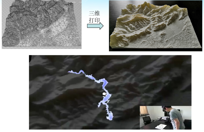
图:基于三维打印地形的堰塞湖溃坝洪水模拟与增强可视化
An efficient flood dynamic visualization approach based on 3D printing and augmented reality
Abstract:Flood visualization is an effective and intuitive tool for representing flood information from abstract spatiotemporal data. With the growing demand for flood disaster visualizations and mitigation, augmented flood visualizations that support decision makers’ perspectives are needed, which can be enhanced by emerging augmented reality (AR) and 3D printing technologies. This paper proposes an innovative flood AR visualization method based on a 3D-printed terrain model and investigates essential techniques, such as the suitable size calculation of the terrain models, the adaptive processing of flood data, and hybridizing virtual flood and terrain models. A prototype experimental system (PES) based on the proposed method and a comparison experimental system (CES) based on a virtual terrain are developed to conduct comparative experiments, which combine the system performance and questionnaire method to evaluate the efficiency and usability of the proposed method. The statistical results indicate that the method is useful for assisting participants in understanding the flood hazard and providing a more intuitive and realistic visual experience compared with that of the traditional AR flood visualization method. The frame rate is stable at 60 frames per second (FPS), which means that the proposed method is more efficient than the traditional AR flood visualization method.
https://blog.sciencenet.cn/blog-113556-1240765.html
上一篇:从虚实关系论虚拟地理环境发展(2017VGE会议交流报告)
下一篇:武大学报2020:基于虚拟眼动实验的指向型应急疏散标识布局优化